Integrated Surface Water –Groundwater Assessments & Modelling
Wetlands and aquatic habitat associated with streams are dependent on groundwater and/or surface water to function. Many of our clients’ projects have the potential to impact these functions and potentially degrade wetlands and/or aquatic habitat. Our multi-disciplinary teams have the knowledge and expertise to assess and monitor the spatial and temporal dynamics of groundwater and/or surface water systems supporting these systems. Armed with our understanding of hydrogeological systems, surface water dynamics, and ecological functions, we can design land-development strategies, water takings, remediation plans, and stormwater management approaches to minimize potential impacts and maintain or restore ecological function.

Key Service Areas include:
- Climate Data Analysis, Climate Change Impacts and Drought Assessments
- Aquatic Habitat and Wetland Assessments
- Groundwater and Hydrological Monitoring
- Water Quality Characterization & Thermal studies
- Ecohydrology and Integrated Surface Water – Groundwater Modelling
- Feature-Based Water Balances and Hydroperiod Analysis
- Baseflow monitoring and shallow monitoring network design
- Times-Series Analysis and 3D Visualization
- Land Use Planning, Environmental Assessments, Cumulative Effects
- Municipal Wellfield Assessment and Source Protection
- Community Development and Stormwater Management
- Subwatershed Studies, Secondary Plans and Municipal Environmental Servicing Plans
- Green Infrastructure and Low Impact Development Best Management Practices
- Mine Water Management
Related Projects
Mine Water and Selenium Management Plan
Matrix was engaged to design a water and selenium management program as part of a Feasibility Study and to complete baseline environmental monitoring and assessments to support the groundwater and surface water components of an EPEA application for the Tent Mountain open pit coal mine project.
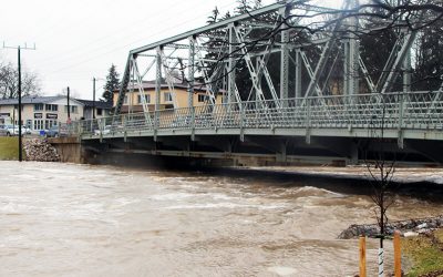
Flood Mitigation Study for New Hamburg
The Town of New Hamburg is located along the Nith River and is one of 27 municipal flood damage centres in the Grand River Conservation Authority’s (GRCA’s) jurisdiction. The Town was established and developed in the Nith River floodplain and is subject to routine nuisance flooding; in addition to significant flooding events in 1975, 2008, and most recently in February 2018 and January 2020. Matrix was retained to estimate average annual flood damage costs associated with existing flooding, develop and evaluate potential mitigation strategies, and provide support for two Public Information Centres (PICs).
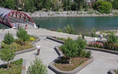
West Eau Claire Park Public Realm Plan
West Eau Claire Park is a popular area along the Bow River, just north and west of downtown and near the iconic Peace Bridge. The City of Calgary wished to connect the community with the Bow River and also provide important flood protection for downtown Calgary. The park was redeveloped through widening and raising the existing pathway, protecting and enhancing the river bank, and grading and landscaping the south overbank area to protect against a 1:200-year flood event with 0.5 m of freeboard.